The next day I woke up with special anticipation, since we planned to visit a place which for me was one of the main reasons to come to this area. Before getting there, we first turned from the paved road onto a dirt road, having previously checked by phone whether its state was good. There we drove through the Valley of the Gods. The area is really beautiful and quite wild, with hardly any presence of civilization except for a small B&B at the end of the road we were on.
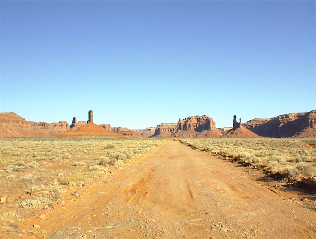 Valley of the Gods (Photograph courtesy of VT)
Then we finally went to the Monument Valley. This is the place few people have not seen for it often features in Hollywood films, usually when the plot takes places in the Wild West, and that was precisely the place I wanted to see the most in this part of the USA. As this area also belongs to the Navajo tribe, it is not allowed to visit it yourself, but rather you must take a Navajo guide. We spent almost three hours driving around the Valley and it all looked magnificent to me. Still, perhaps the most remarkable impression was when we got to a large rock formation that was hollow and that was reminiscent of a huge hogan (a Navajo hut). Somewhere towards its top there was a natural opening in the stone where with a little bit of imagination one could see a “hidden” image of an eagle. When we got there, Rich, our guide, told us to lie on an inclined rock shone-upon by the sun, to leave our cameras aside and just relax. When we did as instructed, in this hollow in the mountain, this open cave of a rounded-top cone shape with fantastic acoustics where everything resonated flawlessly, he started to sing a mesmerizingly beautiful song in Navajo that automatically transported us into some other realm of existence. The warm sunrays, beautiful song and complete tranquillity, everything was so magnificent, simple and perfect that I wished I could stay there and then for all eternity.
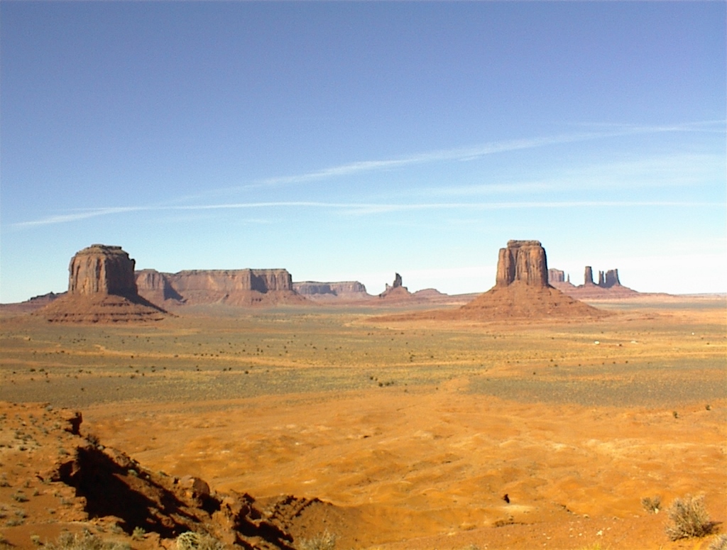 Monument Valley (Photograph courtesy of VT)
But, our journey forced us to move forward and it was to a place named Kayenta, where we made a stop at the local Burger King. The reason was very particular. This is a unique Burger King restaurant in the world, for it holds a special exhibit dedicated to “Navajo Code Talkers.” These were solders from the Navajo nation who fought in WWII. Namely, the American army had huge problems with the Japanese at the time, since the latter managed to break each code the former came up with. Then finally it occurred to the Americans to try to use the language of the Navajos, which was also coded for the purpose. As it turned out, the Japanese never managed to break it, but the world first heard about it only in 1968 when the story was declassified, that is, when it was allowed to publicise it. It was only in 1969 that the participants in this action got due medals and public recognitions. Before then, even they had not said a word about it and had honourably kept the secret. A number of U.S. presidents have paid tribute and expressed gratitude for all of this.
That day we also managed to reach Lake Powell that was created when a dam was built in the Glen canyon. Some people claim that this canyon was perhaps even more beautiful than the Grand Canyon, albeit smaller. Still, the dam was finished in 1963, the lake was filled until 1980 and today it is a popular place for leisure and recreation with a large marina. My friend and I had an intention to go and visit the biggest stone arch in the world, named Rainbow bridge, that was in the vicinity, but we neither had the time for it nor were any organized tours that day and the next one as it was the low season.
The view at the lake from an elevation where we parked our car looked quite unreal because of the rounded rock shores, a lot of bays and fjords, which under the setting sun and with different colours of the sedimentary rocks rendered the entire area a completely extraterrestrial appearance. We came down to the lake itself, but there was really nothing for us to do, so we went to a nearby town and a warmly recommended Mexican restaurant. Chicken fajitas were delicious.
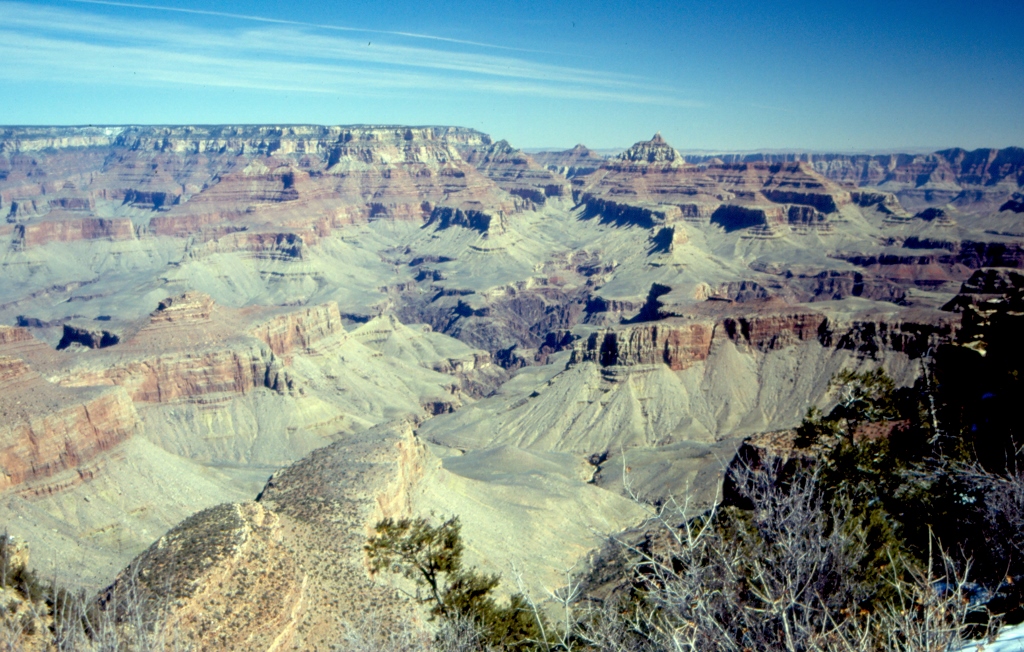
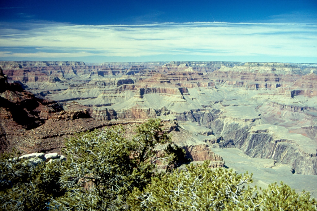
We also looked at the Grand Canyon, which can be visited within a national park of the same name, from above, following its south rim. This is the biggest canyon in the world, but the entire Grand Canyon complex has not been made only through the action of the Colorado, which is the biggest there, but there are also other water flows created from melting snows or there used to be other small rivers that have dried up in the meantime leaving only dried river beds behind. Thanks to the millions of years of erosion, today there is a whole system of mini canyons and gorges there, and not only one. It is all indeed grand and impressive. Standing before such a sight that expands in front of your eyes, you realize all the limitations of photography and video recordings. A photo is a photo and it is accurate, but the problem arises when you realize that it lacks images caught by your periphery vision, it lacks the wind in your hair, the sun that warms you, the feelings that permeate you at that moment, the sounds of the wind blows or the buzzing of tourists around you.
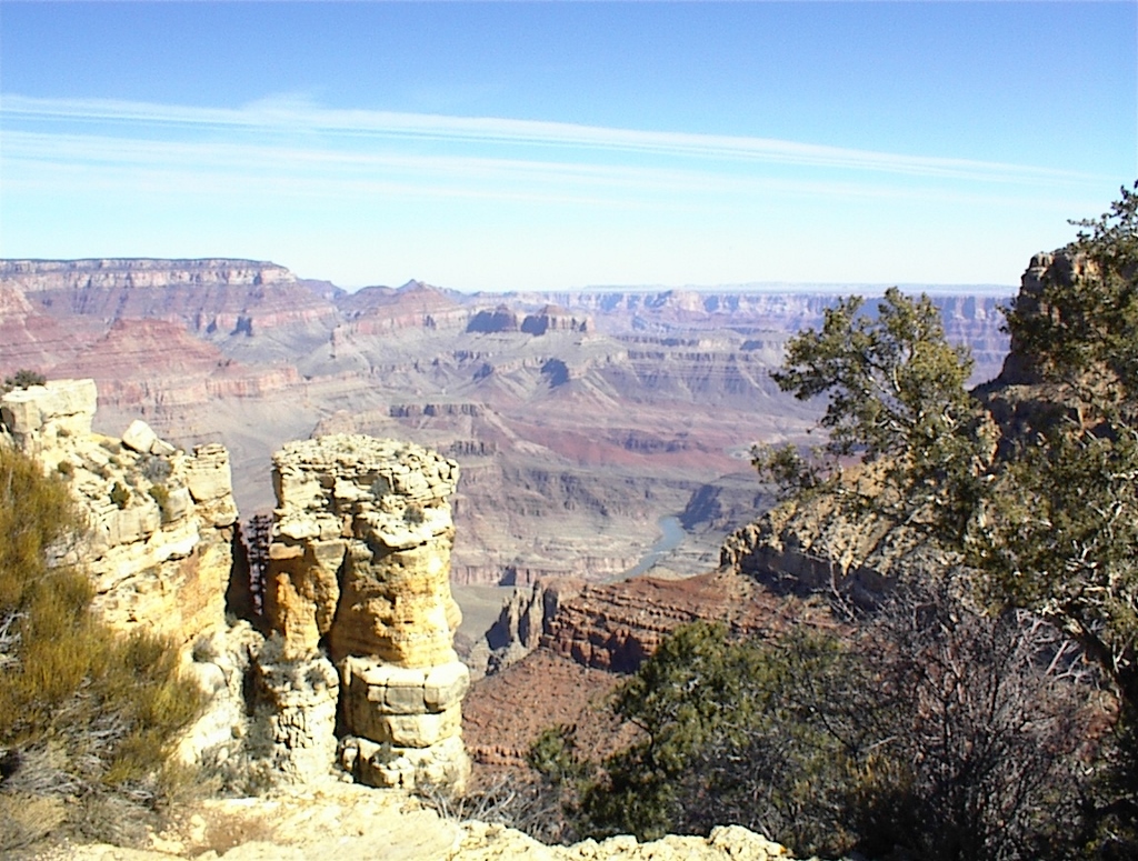 Grand Canyon NP – with the Colorado in the centre (Photograph courtesy of VT)
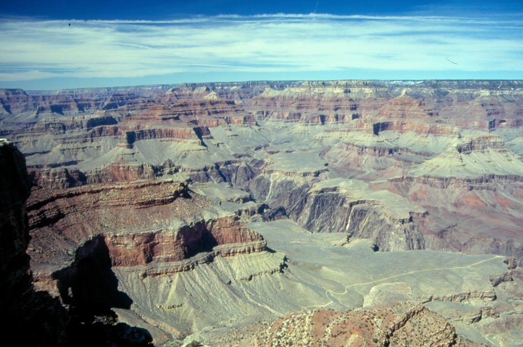
The canyon complex can be watched from a large number of viewpoints. Different rock formations that can be seen have been given picturesque names: Isis Temple, Buddha Temple, Vishnu Temple, etc. There are also two hiking trails that lead to the Colorado; one is around 11 km long and the other one around 14 km. This may not sound like much until you realize that the altitude difference between the rim and the Colorado in that area is around 1800 m.
 Grand Canyon NP – a hiking trail leading to the Colorado is in the lower right corner
 Grand Canyon NP
The Grand Canyon is bordered by two large dams, the Glen Canyon dam and Lake Powell upstream, and the Hoover dam and Lake Mead downstream, and it is 446 km long. The average width of the canyon from the north to the south rim is 16 km. The average depth from the rim to the river is 1525 m, but one needs to bear in mind that the north rim is some 300 m higher than the south rim, since the south rim is at 2173 m above sea level and the north rim is at 2483 m. It is interesting that the temperatures on both rims can sometimes be as much as 17°C lower than the temperature at the level of the river on account of wind and exposure to other meteorological influences.
 Grand Canyon NP
As for the geological characteristics, they can be observed very well, since some 1500 m to 1600 m on an average have been carved through the rocks. From the top towards the bottom, one can see limestone, mixture of limestone and sandstone, or only sandstone (205 million years old), then again different types of sandstone, limestone and shale. The age of the lowest level goes from 800 million years to 1.2 billion years. That is the so-called Grand Canyon super group which consists of sedimentary rocks and lava.
The day when we visited the Grand Canyon National Park the visibility was good since it was quite windy. Otherwise, because of the pollution of the air coming from California, the entire landscape can be covered in haze leading to poor visibility. On the other hand, there we encountered another type of pollution and that was pollution created by noise and people, which we were inevitably a part of. Let me make it clearer, it was a Sunday and a truly beautiful, sunny day, ideal for an outing, so a lot of people came from the nearby towns to enjoy the scenery, just like us. But, we had met very few people during the visits of the previous days and had been lucky enough to enjoy the settings one on one and to listen only to the sounds of nature and possibly those of our breathing. After that, the crowd we came across when visiting the Grand Canyon really appeared like a pollution of nature. Ever since then, my friend and I like to joke that tourists should be banished by law, always, of course, provided it did not apply to us.
After the Grand Canyon, we went to a place called Meteor Crater and this is where the biggest visible point of a meteor’s impact in the world can be seen. When 50,000 ago a meteor, with a 50 m diameter, hit the Earth practically at a right angle, it created a crater of almost 2 km-diameter and around 200 m deep. In the past, this location was used for astronauts practicing walking on the Moon. Well, we reached this crater some 10 minutes too late, it was closed for visits for the day and we could only look at the rim of the crater from outside.
The last day of our trip we had to take into account the departure time of our flight, so we headed for Las Vegas. Still, our visits and stops were not over. The road leads over the Hoover Dam, built between 1931 and 1936. Originally it was called the Boulder Dam, after a nearby place, but in 1947 it was renamed after one of the American presidents. At the time it was the biggest dam on the Colorado creating an artificial lake behind it called Lake Mead. This entire complex is considered a place of national importance.
It is interesting that the water never goes over the dam, but rather through special tunnels, pipes and canals where it runs over turbines. The dam was built in the Black Canyon, thus called on account of the black rocks that predominate there. When the lake was made, the water reached a certain height, but when the water level decreases, one can see rocks that are now completely white. In this way, it is possible to clearly observe the maximum level of water collected in the lake.
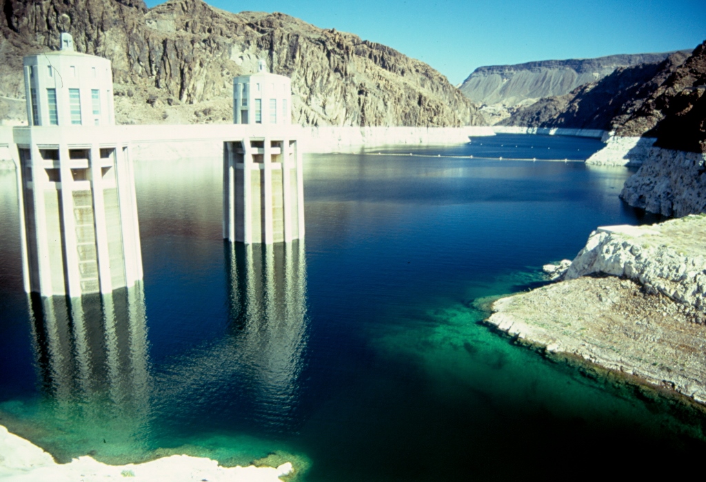 Lake Mead
The road for vehicle goes literally over the dam and it is also possible to cross the dam on foot. Somewhere around the middle of the dam there is a board that shows that the state of Nevada is on one side and Arizona is on the other. This is also a border between two time zones, so when we were there it was 11 o’clock in Arizona and 10 o’clock in Nevada. When standing by the board, one of us was on one side and the other was on the other side, so since these were two different states and two different time zones, we realized we were neither at the same place nor at the same time and yet we were together. There is the evidence that everything is relative.
I think it is quite clear from my account that one week is simply not enough to visit this area the way it deserves. Also, it is probably better to come here during high season because access is easier to some places, but, since this is a semi-desert, temperatures can be quite high during summer which again has its specific shortcomings. In addition, I can only imagine the number of visitors during summer, with all the crowds and noise, that can be an impediment of its own kind. Personally, I’m extremely glad I have seen this in the first place. Second, I am actually very glad that I was there during a low season and still lucky with the weather, as it could have been cloudy and with unpleasant weather conditions all the time. And finally, something very unusual and extraordinary happened to me there – somehow I managed to lose a video tape and also the vast majority of my photos were inexplicably overexposed. I’m not particularly superstitious, but I like to interpret this as a “sure sign” that I will return and visit again these magnificent “islands” somewhere between the earth and the sky.