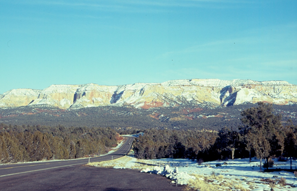
After the first section of the road with numerous curves, we got to a highland plateau with quite a lot of snow. Along the way we saw deer at several points and we also came across some wild turkeys which made us stop since they were crossing the road when we came along. The colours around us were truly beautiful – in the distance in front of us across the plateau there were mountains of yellowish and red colour, there were evergreen trees and snow that alternately covered patches of ground around us, and the sky had cleared up in the meantime displaying its beautiful winter shade of blue.
We were driving in the direction of another national park on our way and that was the Bryce Canyon NP. By the way, the entire south section of Utah and the north section of Arizona belong to the same geological formation that involves a lot of canyons. Thus, the road took us through Red Canyon. It was already late afternoon, the sun was close to setting and that rendered an intense colour to the red rocks we were driving by. Both the colour and the shape of these rocks were really very attractive and interesting.
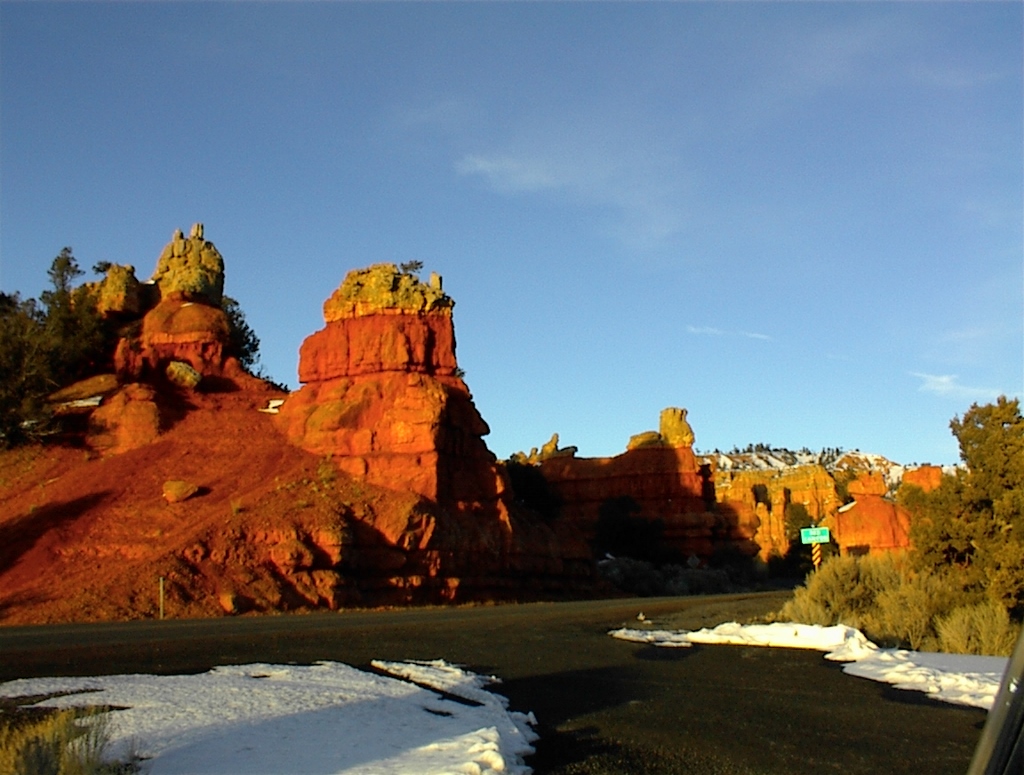 Red Canyon (Photograph courtesy of VT)
We reached the Bryce Canyon NP in the evening, but regardless of the darkness we went to one of the viewpoints and thanks to the reflection of the snow it was quite clear that the scenery was exceptional. We were at around 2500 m above sea level, it was evening, beginning of March and there was snow all around us, which meant it was freezing. So, we dwelled there only for a little while and then went to a nearby motel for the night.
The morning was significantly more pleasant, still cold, but not as much as the evening before. In addition, the sun was shining in a cloudless sky. There was snow everywhere, except on the road we were on, and everything looked wonderful. But, when we started visiting the viewpoints, we were stunned by the breathtaking beauty that lay down in front of us. We decided to walk a little, but very carefully, since we didn’t have proper waterproof footwear, so we tried just to follow a path made in the snow. I don’t know how, but I did manage to fall into the snow up to my “derriere,” which in fact served scientific purposes of establishing that the layer of snow in that point exceeded 1 meter. Velislav started to pull me out, but he also managed to get stuck in the snow. Still, thanks to him we did manage to get out eventually, but the “rescue operation” was seriously impeded by our continuous laughter.
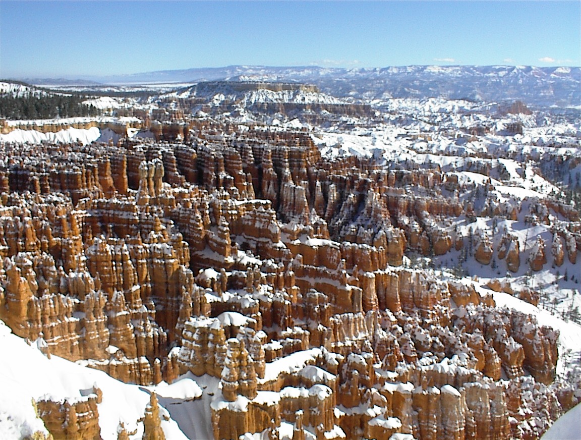 Bryce Canyon NP (Photograph courtesy of VT)
What gives special charm to the Bryce Canyon National Park are stone towers packed up tightly like honey-comb and grouped up within different natural amphitheatres. The dominant red colour is caused by the iron present in the rocks and some find this to be the most intense red colour of rock in the world. What happens with these towers is that they are covered by snow for some 200 days a year. During the day, the snow melts and at night the thawed water freezes again, which is the reason for getting these fantastic shapes and forms. The eroded sandstone formations are called the hoodoos. In one of such amphitheatres we came across a well formed path and since I had shoes that were not slippery, I ventured a little down into the amphitheatre in order to get better views. Going along the path I could see a lot of small arches or holes within the rocks around me and when I would look up that was particularly great – the brightly red rocks around me, the white show and the dazzling blue sky above.
 In one of the Bryce Canyon NP’s amphitheatres (Photograph courtesy of VT)
In addition to the action of wind, water in liquid form and ice that help shape the rocks, a significant mark on the change of the environment has been left and is being left by man. In the beginning it was by grazing cattle and cutting down trees, which led to the disappearance of the beaver, wolf and grizzly bear, but even today, when this is a protected area, there is an increased noise and air pollution caused by the people who are being attracted to come here in the first place.
However, no matter how much we loved it here, we had to go on. More or less on our way was a state park named Kodachrome Basin. It was entitled in this way because in 1949 it was visited by a National Geographic Society’s expedition which named the entire area “Kodachrome plain” in honour of the photography film. I take it that it is rather likely that the company Kodak was their sponsor. Anyway, the state park is known for its rock pillars, vertical stone chimneys, that are naturally scattered across a flat terrain. The best known is a lonely rock appropriately named the Chimney Rock. It has not moved in the slightest since 1949 when it was probably filmed for the first time. Be as it may, it was not cold here, there was no snow and the ground appeared completely dry and solid. When we started to walk there in order to see the Chimney Rock better and take photos, it turned out that the apparently dry layer of soil hid a lot of mud that was particularly sticky. With each step our legs were getting heavier and we eventually barely managed to take all of that mud off our shoes.
As we drove further, we saw to our left a beautiful mountain range with Powell Point (3105 m) dominating it. It was named after John Wesley Powell, an explorer of the Green and Colorado rivers who organized several expeditions in this part of the USA in the second half of the 19th century and who paved the way for future explorers by drawing maps of until then unknown areas.
The road we took passes through very scenic and diversely beautiful areas. It goes across a highland plateau for a little while, then through a canyon or a gorge, then there are rivers, multi-coloured rocks, with or without snow, and evergreen trees, and it is easy to make a stop and admire this in peace because there are very frequent viewpoint parking lots. These are in fact expanded paved areas along the road made specifically in the locations from which there is a fine view. At one point the road led along a mountain ridge, as if along a natural bridge. To the left and right of the road one could see a few meters of ground which slowly disappeared downwards and then – nothing, except for the landscape in the distance. At one moment the width of the ridge was the same as the width of the road. We certainly did not stop there, but there was neither any need to drive fast, there were almost no other cars around and it would have been a pity not to take a good look as we passed a herd of does grazing by the road.
Thus we reached the next national park on our way and it was the Capitol Reef National Park. Most of the day was already gone and we realized we didn’t have a lot of time, so we agreed to visit what we could reach by car, since there was no way we could take a walk. As it turned out, it was precisely by car that we could visit a couple of interesting places, but what is considered particularly worthwhile in this park, such as arches and similar formations, can be reached only on foot. As for those stone arches, it is possible to see on a large number of cliffs how exactly they are being shaped up. So, you see a vertical rock and a very clearly visible arch in the making. Sometimes it is but a hint, a drawing-like line in the stone, but sometimes you see an arched overhang. Just a few million years more and there we have a proper free standing arch.
We got off the asphalt road and literally entered into the mountain range following a dirt road that meandered in front of us. This is a path one follows in order to walk later on to the Cassidy Arch, named after Butch Cassidy who is said to have been hiding there. I know for a fact that I would not fancy the original, for I don’t like thieves as a matter of principle, but when I would think of Robert Redford and Paul Newman (whoever played him in the romanticized film version) I would immediately get a fuzzy feeling around my heart thinking that perhaps even then one of them might be hiding behind some rock. Anyway, we drove to an expanded clearing which was at the same time the end of the dirt road and we got out of the car to have a better view at the environs. There was no way we could walk anywhere, it was already past 5 pm, but we tried out echo in this spot and it was amazing.
We got back to the paved road for a short while and then turned again to another dirt road that led through Capitol Gorge. Here the road runs for over 2 km. In the middle there is another plot for vehicles and this is regularly cleared. Back in 1884, some two guys cleared this place up in order to allow carts to pass through, but because of frequent torrents that carry stones, regular maintenance is inevitable. At the time we were there, the road was occasionally covered with remains of snow and ice and then it would lead across a dry riverbed, but all the time it wound between vertical high rocks and sometimes it appeared just slightly wider than the width of the car. When we reached the end of the dirt road, we also got out of the car in order to absorb the images around us. It was wonderful and the impression was increased by the fact that we were completely alone.
By the way, the first Mormon settlers named this area Capitol Reef. The reason for the latter part of the name is that this mountain massif creates a natural barrier in a way a reef separates shallows from the deep sea. The other part of the name comes from the shape of one of the high rocks that reminds of the Congress building in Washington D.C. The first settlers are also important, among other reasons, because they started to grow fruit here. Everywhere around there is desert, but here there are natural water reservoirs that collect rainwater, so orchards could grow fruits. Those orchards exist even today and are a part of the National Park, but in season tourists are allowed to pick ripe fruits.
When we left the National Park it was getting seriously late and the sunrays reached only the mountaintops, but because of the specific effects of the setting sun we could enjoy fantastic bright colours. And then, just some 15 minutes later, outside the national park, we entered a landscape that made us feel as if on the Moon. Everything was gray, even some building we saw there, with practically no vegetation to speak of, and yet it wasn’t any less beautiful in its own unusual way.